Isaias Expected To Intensify Monday, Then Move Up East Coast
Tyler Durden
Mon, 08/03/2020 - 08:50
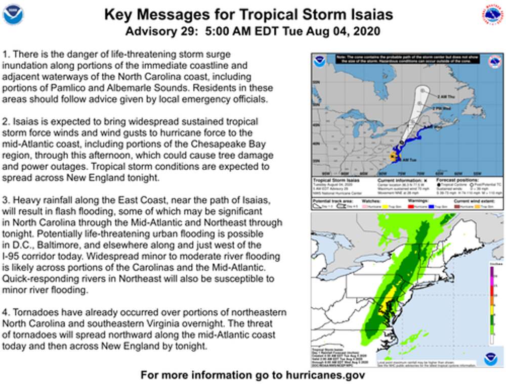
Tropical Storm Isaias is expected to become a hurricane as it nears the Carolinas on Monday evening, according to the National Hurricane Center (NHC).
\x3csource srcset=\"https://zh-prod-1cc738ca-7d3b-4a72-b792-20bd8d8fa069.storage.googleapis.com/s3fs-public/styles/inline_image_desktop/public/inline-images/2020-08-06_05-29-55.png?itok=GyWSWLZx 1x\" media=\"all and (min-width: 1280px)\" type=\"image/png\">\x3c/source>\x3csource srcset=\"https://zh-prod-1cc738ca-7d3b-4a72-b792-20bd8d8fa069.storage.googleapis.com/s3fs-public/styles/inline_image_desktop/public/inline-images/2020-08-06_05-29-55.png?itok=GyWSWLZx 1x\" media=\"all and (min-width: 480px)\" type=\"image/png\">\x3c/source>\x3csource srcset=\"https://zh-prod-1cc738ca-7d3b-4a72-b792-20bd8d8fa069.storage.googleapis.com/s3fs-public/styles/inline_image_desktop/public/inline-images/2020-08-06_05-29-55.png?itok=GyWSWLZx 1x, https://zh-prod-1cc738ca-7d3b-4a72-b792-20bd8d8fa069.storage.googleapis.com/s3fs-public/styles/inline_image_desktop/public/inline-images/2020-08-06_05-29-55.png?itok=GyWSWLZx 2x\" media=\"all and (min-width: 1024px)\" type=\"image/png\">\x3c/source>\x3csource srcset=\"https://zh-prod-1cc738ca-7d3b-4a72-b792-20bd8d8fa069.storage.googleapis.com/s3fs-public/styles/inline_image_desktop/public/inline-images/2020-08-06_05-29-55.png?itok=GyWSWLZx 1x\" media=\"all and (min-width: 768px)\" type=\"image/png\">\x3c/source>\x3csource srcset=\"https://zh-prod-1cc738ca-7d3b-4a72-b792-20bd8d8fa069.storage.googleapis.com/s3fs-public/styles/inline_image_mobile/public/inline-images/2020-08-06_05-29-55.png?itok=f6Gw6fk7 1x\" type=\"image/png\">\x3c/source>\x3c!--[if IE 9]>\x3c/video>\x3c![endif]-->\x3cimg data-entity-type=\"file\" data-entity-uuid=\"6c9354b6-4d85-461e-9746-90135044f744\" data-responsive-image-style=\"inline_images\" height=\"506\" width=\"500\" src=\"//mtdata.ru/u16/photo03CF/20478121439-0/original.png#20478121439\" alt=\"\" typeof=\"foaf:Image\" />\x3c/picture>\x3c/a>\x3c/p>\n\n\x3cp>At one point, nearly 100 tornado warnings were issued across ten states as the storm raced up the East Coast. \x3c/p>\n\n\x3cp>\x3cspan aria-label=\"image widget\" role=\"region\" tabindex=\"-1\">\x3ca data-image-external-href=\"\" data-link-option=\"1\" data-widget=\"image\" href=\"\" target=\"_blank\">\x3cimg alt=\"\" data-entity-type=\"\" data-entity-uuid=\"\" data-responsive-image-style=\"\" height=\"281\" src=\"//mtdata.ru/u16/photoF17F/20147339986-0/original.png#20147339986\" width=\"500\" />\x3c/a>\x3c/span>\x3c/p>\n\n\x3cp>Isaias spawned at least a dozen confirmed twisters. \x3c/p>\n\n\x3cp>\x3ca data-image-external-href=\"\" data-image-href=\"/s3/files/inline-images/confirmed%20twisters.jpg?itok=sohXhuSb\" data-link-option=\"0\" href=\"https://www.zerohedge.com/s3/files/inline-images/confirmed%20twisters.jpg?itok=sohXhuSb\" target=\"_blank\">\x3cpicture>\x3c!--[if IE 9]>\x3cvideo style=\"display: none;\">\x3c![endif]-->\x3csource srcset=\"https://zh-prod-1cc738ca-7d3b-4a72-b792-20bd8d8fa069.storage.googleapis.com/s3fs-public/styles/inline_image_desktop/public/inline-images/confirmed%20twisters.jpg?itok=lQ6CDUU6 1x\" media=\"all and (min-width: 1280px)\" type=\"image/jpeg\">\x3c/source>\x3csource srcset=\"https://zh-prod-1cc738ca-7d3b-4a72-b792-20bd8d8fa069.storage.googleapis.com/s3fs-public/styles/inline_image_desktop/public/inline-images/confirmed%20twisters.jpg?itok=lQ6CDUU6 1x\" media=\"all and (min-width: 480px)\" type=\"image/jpeg\">\x3c/source>\x3csource srcset=\"https://zh-prod-1cc738ca-7d3b-4a72-b792-20bd8d8fa069.storage.googleapis.com/s3fs-public/styles/inline_image_desktop/public/inline-images/confirmed%20twisters.jpg?itok=lQ6CDUU6 1x, https://zh-prod-1cc738ca-7d3b-4a72-b792-20bd8d8fa069.storage.googleapis.com/s3fs-public/styles/inline_image_desktop/public/inline-images/confirmed%20twisters.jpg?itok=lQ6CDUU6 2x\" media=\"all and (min-width: 1024px)\" type=\"image/jpeg\">\x3c/source>\x3csource srcset=\"https://zh-prod-1cc738ca-7d3b-4a72-b792-20bd8d8fa069.storage.googleapis.com/s3fs-public/styles/inline_image_desktop/public/inline-images/confirmed%20twisters.jpg?itok=lQ6CDUU6 1x\" media=\"all and (min-width: 768px)\" type=\"image/jpeg\">\x3c/source>\x3csource srcset=\"https://zh-prod-1cc738ca-7d3b-4a72-b792-20bd8d8fa069.storage.googleapis.com/s3fs-public/styles/inline_image_mobile/public/inline-images/confirmed%20twisters.jpg?itok=sohXhuSb 1x\" type=\"image/jpeg\">\x3c/source>\x3c!--[if IE 9]>\x3c/video>\x3c![endif]-->\x3cimg data-entity-type=\"file\" data-entity-uuid=\"fcfeb79b-f30b-4d68-9a91-2e40f5f5883e\" data-responsive-image-style=\"inline_images\" height=\"282\" width=\"500\" src=\"//mtdata.ru/u16/photo0CEA/20593485684-0/original.jpg#20593485684\" alt=\"\" typeof=\"foaf:Image\" />\x3c/picture>\x3c/a>\x3c/p>\n\n\x3cp>Here's some video of the damage:\x3c/p>\n\n\x3cp>The aftermath of a tornado in Doylestown, Pennsylvania. \x3c/p>\n\n\x3cblockquote class=\"twitter-tweet\">\n\x3cp dir=\"ltr\" lang=\"en\" xml:lang=\"en\">TORNADO DAMAGE IN DOYLESTOWN, PENNSYLVANIA\x3cbr />\x3cbr />\nVideo taken from \x3ca href=\"https://twitter.com/hashtag/Doylestown?src=hash&ref_src=twsrc%5Etfw\" target=\"_blank\">#Doylestown\x3c/a> Hospital in SE PA shows significant tornado damage, including overturned cars. \x3ca href=\"https://twitter.com/hashtag/Isaias?src=hash&ref_src=twsrc%5Etfw\" target=\"_blank\">#Isaias\x3c/a> \x3ca href=\"https://t.co/hO1aSxp8Qr\" target=\"_blank\">pic.twitter.com/hO1aSxp8Qr\x3c/a>\x3c/p>\n— Ben Ames (@BenAmesWx) \x3ca href=\"https://twitter.com/BenAmesWx/status/1290690888063221761?ref_src=twsrc%5Etfw\" target=\"_blank\">August 4, 2020\x3c/a>\n\x3c/blockquote>\n\x3cscript async=\"\" src=\"https://platform.twitter.com/widgets.js\" charset=\"utf-8\">\x3c/script>\x3cp>Buildings ripped apart in Dover, Deleware. \x3c/p>\n\n\x3cp>\x3ca data-image-external-href=\"\" data-image-href=\"/s3/files/inline-images/dover%20twister.png?itok=uDmM9sZZ\" data-link-option=\"0\" href=\"https://www.zerohedge.com/s3/files/inline-images/dover%20twister.png?itok=uDmM9sZZ\" target=\"_blank\">\x3cpicture>\x3c!--[if IE 9]>\x3cvideo style=\"display: none;\">\x3c![endif]-->\x3csource srcset=\"https://zh-prod-1cc738ca-7d3b-4a72-b792-20bd8d8fa069.storage.googleapis.com/s3fs-public/styles/inline_image_desktop/public/inline-images/dover%20twister.png?itok=3USRWKAL 1x\" media=\"all and (min-width: 1280px)\" type=\"image/png\">\x3c/source>\x3csource srcset=\"https://zh-prod-1cc738ca-7d3b-4a72-b792-20bd8d8fa069.storage.googleapis.com/s3fs-public/styles/inline_image_desktop/public/inline-images/dover%20twister.png?itok=3USRWKAL 1x\" media=\"all and (min-width: 480px)\" type=\"image/png\">\x3c/source>\x3csource srcset=\"https://zh-prod-1cc738ca-7d3b-4a72-b792-20bd8d8fa069.storage.googleapis.com/s3fs-public/styles/inline_image_desktop/public/inline-images/dover%20twister.png?itok=3USRWKAL 1x, https://zh-prod-1cc738ca-7d3b-4a72-b792-20bd8d8fa069.storage.googleapis.com/s3fs-public/styles/inline_image_desktop/public/inline-images/dover%20twister.png?itok=3USRWKAL 2x\" media=\"all and (min-width: 1024px)\" type=\"image/png\">\x3c/source>\x3csource srcset=\"https://zh-prod-1cc738ca-7d3b-4a72-b792-20bd8d8fa069.storage.googleapis.com/s3fs-public/styles/inline_image_desktop/public/inline-images/dover%20twister.png?itok=3USRWKAL 1x\" media=\"all and (min-width: 768px)\" type=\"image/png\">\x3c/source>\x3csource srcset=\"https://zh-prod-1cc738ca-7d3b-4a72-b792-20bd8d8fa069.storage.googleapis.com/s3fs-public/styles/inline_image_mobile/public/inline-images/dover%20twister.png?itok=uDmM9sZZ 1x\" type=\"image/png\">\x3c/source>\x3c!--[if IE 9]>\x3c/video>\x3c![endif]-->\x3cimg data-entity-type=\"file\" data-entity-uuid=\"7edeb009-e27c-4e58-91f0-91037456d754\" data-responsive-image-style=\"inline_images\" height=\"286\" width=\"500\" src=\"//mtdata.ru/u16/photo1284/20262704231-0/original.png#20262704231\" alt=\"\" typeof=\"foaf:Image\" />\x3c/picture>\x3c/a>\x3c/p>\n\n\x3cp>Tornado touched down in Cape May, New Jersey. \x3c/p>\n\n\x3cblockquote class=\"twitter-tweet\">\n\x3cp dir=\"ltr\" lang=\"en\" xml:lang=\"en\">BREAKING: Tornado touches down in Cape May, NJ as Tropical Storm Isaias moves up East Coast - WPIX\x3ca href=\"https://twitter.com/NorEasterNick?ref_src=twsrc%5Etfw\" target=\"_blank\">@NorEasterNick\x3c/a>\x3cbr />\x3cbr />\x3ca href=\"https://t.co/EJ5EJVuURW\" target=\"_blank\">pic.twitter.com/EJ5EJVuURW\x3c/a>\x3c/p>\n— Breaking911 (@Breaking911) \x3ca href=\"https://twitter.com/Breaking911/status/1290667312371109896?ref_src=twsrc%5Etfw\" target=\"_blank\">August 4, 2020\x3c/a>\n\x3c/blockquote>\n\x3cscript async=\"\" src=\"https://platform.twitter.com/widgets.js\" charset=\"utf-8\">\x3c/script>\x3cp>Homes damaged in Maryland.\x3c/p>\n\n\x3cblockquote class=\"twitter-tweet\">\n\x3cp dir=\"ltr\" lang=\"en\" xml:lang=\"en\">Here are some more pictures of the Eastern Shore tornado damage after \x3ca href=\"https://twitter.com/hashtag/Isaias?src=hash&ref_src=twsrc%5Etfw\" target=\"_blank\">#Isaias\x3c/a> \x3ca href=\"https://twitter.com/wjz?ref_src=twsrc%5Etfw\" target=\"_blank\">@wjz\x3c/a> \x3ca href=\"https://t.co/bGW9vd94Kv\" target=\"_blank\">pic.twitter.com/bGW9vd94Kv\x3c/a>\x3c/p>\n— Mike Hellgren (@HellgrenWJZ) \x3ca href=\"https://twitter.com/HellgrenWJZ/status/1291082421786628102?ref_src=twsrc%5Etfw\" target=\"_blank\">August 5, 2020\x3c/a>\n\x3c/blockquote>\n\x3cscript async=\"\" src=\"https://platform.twitter.com/widgets.js\" charset=\"utf-8\">\x3c/script>\x3cp>\"Damage from isaias in Courtland va I worked down there today it was unreal first real tornado damage I’ve seen first hand,\" said one Twitter user.\x3c/p>\n\n\x3cblockquote class=\"twitter-tweet\">\n\x3cp dir=\"ltr\" lang=\"en\" xml:lang=\"en\">Damage from isaias in Courtland va I worked down there today it was unreal first real tornado damage I’ve seen first hand \x3ca href=\"https://twitter.com/MegWiseNBC12?ref_src=twsrc%5Etfw\" target=\"_blank\">@MegWiseNBC12\x3c/a> \x3ca href=\"https://twitter.com/AndrewNBC12?ref_src=twsrc%5Etfw\" target=\"_blank\">@AndrewNBC12\x3c/a> \x3ca href=\"https://twitter.com/NBC12?ref_src=twsrc%5Etfw\" target=\"_blank\">@NBC12\x3c/a> \x3ca href=\"https://twitter.com/StephanieAbrams?ref_src=twsrc%5Etfw\" target=\"_blank\">@StephanieAbrams\x3c/a> \x3ca href=\"https://twitter.com/JimCantore?ref_src=twsrc%5Etfw\" target=\"_blank\">@JimCantore\x3c/a> \x3ca href=\"https://t.co/dHgWHBGeqi\" target=\"_blank\">pic.twitter.com/dHgWHBGeqi\x3c/a>\x3c/p>\n— Jamie (@JLynchRVA) \x3ca href=\"https://twitter.com/JLynchRVA/status/1291184153409486848?ref_src=twsrc%5Etfw\" target=\"_blank\">August 6, 2020\x3c/a>\n\x3c/blockquote>\n\x3cscript async=\"\" src=\"https://platform.twitter.com/widgets.js\" charset=\"utf-8\">\x3c/script>\x3cp>What Americans saw on the news this week... \x3c/p>\n\n\x3cp>\x3ca data-image-external-href=\"\" data-image-href=\"/s3/files/inline-images/news.png?itok=P3ZjPlfL\" data-link-option=\"0\" href=\"https://www.zerohedge.com/s3/files/inline-images/news.png?itok=P3ZjPlfL\" target=\"_blank\">\x3cpicture>\x3c!--[if IE 9]>\x3cvideo style=\"display: none;\">\x3c![endif]-->\x3csource srcset=\"https://zh-prod-1cc738ca-7d3b-4a72-b792-20bd8d8fa069.storage.googleapis.com/s3fs-public/styles/inline_image_desktop/public/inline-images/news.png?itok=K1_v1AWt 1x\" media=\"all and (min-width: 1280px)\" type=\"image/png\">\x3c/source>\x3csource srcset=\"https://zh-prod-1cc738ca-7d3b-4a72-b792-20bd8d8fa069.storage.googleapis.com/s3fs-public/styles/inline_image_desktop/public/inline-images/news.png?itok=K1_v1AWt 1x\" media=\"all and (min-width: 480px)\" type=\"image/png\">\x3c/source>\x3csource srcset=\"https://zh-prod-1cc738ca-7d3b-4a72-b792-20bd8d8fa069.storage.googleapis.com/s3fs-public/styles/inline_image_desktop/public/inline-images/news.png?itok=K1_v1AWt 1x, https://zh-prod-1cc738ca-7d3b-4a72-b792-20bd8d8fa069.storage.googleapis.com/s3fs-public/styles/inline_image_desktop/public/inline-images/news.png?itok=K1_v1AWt 2x\" media=\"all and (min-width: 1024px)\" type=\"image/png\">\x3c/source>\x3csource srcset=\"https://zh-prod-1cc738ca-7d3b-4a72-b792-20bd8d8fa069.storage.googleapis.com/s3fs-public/styles/inline_image_desktop/public/inline-images/news.png?itok=K1_v1AWt 1x\" media=\"all and (min-width: 768px)\" type=\"image/png\">\x3c/source>\x3csource srcset=\"https://zh-prod-1cc738ca-7d3b-4a72-b792-20bd8d8fa069.storage.googleapis.com/s3fs-public/styles/inline_image_mobile/public/inline-images/news.png?itok=P3ZjPlfL 1x\" type=\"image/png\">\x3c/source>\x3c!--[if IE 9]>\x3c/video>\x3c![endif]-->\x3cimg data-entity-type=\"file\" data-entity-uuid=\"e45603ba-1d5e-4117-85f4-6b438372f145\" data-responsive-image-style=\"inline_images\" height=\"284\" width=\"500\" src=\"//mtdata.ru/u16/photoB614/20708849929-0/original.png#20708849929\" alt=\"\" typeof=\"foaf:Image\" />\x3c/picture>\x3c/a>\x3c/p>\n\n\x3cp>Stressful times.\x3c/p>\n\x3c/div>\x3cimg src=\"//mtdata.ru/u16/photo0180/20154995627-0/original.gif#20154995627\" height=\"1\" width=\"1\" alt=\"\" />","comments_count":0,"marks_count":0,"likes":{"count":0,"user_likes":0,"can_like":0,"marks_pluses":0,"marks_minuses":0,"user_like_attr":null,"like_attr_ids":[]},"fame_actions_positive_count":0,"fame_actions_negative_count":0,"fame_actions":[],"url":"https://zerohedge.mirtesen.ru/blog/43001796161","tags":["Isaias"],"date":1596712184,"canEdit":false,"foreignPollId":null,"attachments":[{"photo":{"id":20031975741,"photo_original":"https://mtdata.ru/u16/photoCE89/20031975741-0/original.png","width":500,"height":714}}],"group":{"display_name":"Zero Hedge","url":"https://zerohedge.mirtesen.ru","photo_original":null,"id":30179668738,"canViewBlogPostCreator":false,"showSubscribersAmount":true,"is_subscribed":false,"is_member":false,"is_owner":false,"is_staff":false,"created":1425661540867},"canonical_url":"http://feedproxy.google.com/~r/zerohedge/feed/~3/ei5U31uWk5Q/isaias-aftermath-2-million-without-power-northeast-dozen-confirmed-tornados","topic":null,"title":"Isaias Aftermath: 2 Million Still Without Power Across Northeast; At Least 12 Tornados Confirmed","preview_text":"Isaias Aftermath: 2 Million Still Without Power Across Northeast; At Least 12 Tornados Confirmed \n Tyler Durden\n \nThu, 08/06/2020 - 07:09\n\n \nTropical Storm Isaias is long gone, but there's widespread damage along the East Coast and more than 2 million homes in the Northeast without","post_type":"post","formattedDates":{"iso":"2020-08-06T11:09:44.000Z","ver1":"6 августа, 14:09","ver2":"06.08.2020 в 14:09","ver3":"6 авг., 14:09"},"images":[{"main":true,"url":"https://mtdata.ru/u16/photoCE89/20031975741-0/original.png","width":500,"height":714}],"videos":[],"shared_post":null,"mentionedPersons":null},{"id":43153702233,"from_id":674176298,"from":{"id":674176298,"display_name":"Казбек Коджешау","url":"https://mirtesen.ru/people/674176298","photo_original":"https://mtdata.ru/u26/photo73AC/20347960376-0/original.jpeg","isAuthenticAccount":false,"sex":2},"owner_id":-30745230817,"text":"\x3cdiv class=\"ui-rss-img-first\">\x3cp>\x3cimg src=\"//mtdata.ru/u2/photo31E4/20558903436-0/original.jpg#20558903436\" />\x3c/p>\x3c/div>\x3cdiv class=\"ui-rss-text\">\x3cp>\x3cp>В США под удар стихии попали штаты Южная и Северная Каролина. Предупреждение о тропическом шторме объявлено на Восточном побережье до границы с Канадой. В Китае ливни обрушились на провинции Чжэцзян и Фуцзянь. 6-7 августа сильные осадки тайфун принесет в Приморский край.\x3c/p>\x3cp>Jonathan Petramala / TwitterВ Атлантическом и Тихом океанах продолжается сезон тропических циклонов. 4 августа сразу два из них вышли на сушу - ураган \"Исайяс\" на востоке США и тайфун \"Хагупит\" на востоке Китая. Примечательно, что в обоих случаях максимальная скорость ветра составляла 136,8 км/ч. \"Исайяс\", от которого ранее пострадали Доминикана, Пуэрто-Рико, Теркс и Кайкос и Багамские острова, у побережья Флориды ослабел до тропического шторма и вновь стал ураганом вблизи Южной Каролины. Он пересек береговую линию на юге Северной Каролины и в настоящее время почти достиг Виргинии, опять став тропическим штормом. Скорость ветра уменьшилась до 110 км/ч, информирует Национальный центр США по слежению за ураганами (NHC). Предупреждение о тропическом шторме действует на Восточном побережье США - от Северной Каролины, где из-за стихии введено чрезвычайное положение, до границы штата Мэн с Канадой. Сложные погодные условия ожидаются также во многих крупных городах, в том числе в Вашингтоне, Нью-Йорке и Филадельфии. Метеорологи предупреждают о сильных осадках, в некоторых районах возможны торнадо. Пока от урагана досталось прибрежным населенным пунктам и островам в штатах Южная и Северная Каролина. Здесь проливные дожди и штормовой нагон привели к наводнениям. Затоплены улицы в городе Уилмингтон, население которого превышает 100 тысяч человек. По данным сервиса PowerOutage.US, в Северной Каролине и Виргинии без света остались 443 тыс. домов. Glad I didn't take off my waders to get to my hotel...the appropriately named \"water street\" in downtown #WilmingtonNC is flooding from the south eye pushing water up the Cape Fear River. #isaias @accuweather pic.twitter.com/X9UZlAPAYP— Jonathan Petramala (@jpetramala) August 4, 2020 One of many cars flooded in downtown #WilmingtonNC by storm surge and #HurricaneIsaias @accuweather #ncwx pic.twitter.com/41WuG8PazS— Jonathan Petramala (@jpetramala) August 4, 2020 В Китае тайфун \"Хагупит\" обрушился на провинцию Чжэцзян. Он вышел на сушу в городском уезде Юэцин и, ослабевая, продолжает движение на восток страны. В провинциях Чжэцзян и Фуцзянь идут проливные дожди. Штормовая погода наблюдалась в западных и южных районах Восточно-Китайского моря, акватории вблизи острова Дяоюйдао, устье Янцзы, а также в заливе Ханчжоувань и прибрежных районах этих провинций, сообщает агентство \"Синьхуа\". По данным на 22:00 3 августа, более 381 тыс. жителей провинции Чжэцзян были эвакуированы в безопасные районы. В провинции Фуцзянь приостановлено строительство и работа железнодорожного транспорта, а суда вернулись в порты. По прогнозам синоптиков, \"Хагупит\", теряя силу, продолжит движение на север со скоростью 20-25 км/ч. Он выйдет в Желтое море, а в среду утром приблизится к западному побережью Корейского полуострова. Предупреждение также объявлено в Приморском крае. В связи с влиянием активных фронтальных разделов на западе края и выходом на акваторию Японского моря тропического циклона 6-7 августа в Приморском крае ожидаются дожди, в отдельных районах сильные (с количеством 15-45 мм за 12 часов и менее), на юго-востоке края утром и днем 6 августа местами очень сильные дожди (50 мм и более за 12 часов и менее), предупреждает Примгидромет. Ночью 7 августа очень сильный дождь (более 50 мм) сохранится на севере восточного побережья края. Дожди будут сопровождаться грозами, в прибрежных районах с ветром 15-22 м/с. Днем в пятницу по району Поворотный-Золотой ожидается высота волн 2,5-3,5 м, в открытой части моря 3-4 м. В бухтах побережья - сильный накат. На реках края вероятно формирование локальных дождевых паводков высотой подъема уровней воды на 0,4-0,9 м, на реках юго-восточных и восточных районов края возможны резкие подъемы воды до 1,4 м, с подтоплением пониженных участков местности от переполнения малых водотоков и интенсивного ливневого стока.Источник\x3c/p>\x3c/p>\x3c/div>\x3cp> \x3c/p>","comments_count":0,"marks_count":0,"likes":{"count":0,"user_likes":0,"can_like":0,"marks_pluses":0,"marks_minuses":0,"user_like_attr":null,"like_attr_ids":[]},"fame_actions_positive_count":0,"fame_actions_negative_count":0,"fame_actions":[],"url":"https://natpressnet.mirtesen.ru/blog/43153702233","tags":["HurricaneIsaias","WilmingtonNC","В Мире","isaias","ncwx"],"date":1596557095,"canEdit":false,"foreignPollId":null,"attachments":[{"photo":{"id":20558903436,"photo_original":"https://mtdata.ru/u2/photo31E4/20558903436-0/original.jpg","width":800,"height":600}}],"group":{"display_name":"NatPress.NET - Национальное Агентство Новостей России","url":"https://natpressnet.mirtesen.ru","photo_original":"//mtdata.ru/u8/photo286C/20558144216-0/original.jpeg","id":30745230817,"canViewBlogPostCreator":false,"showSubscribersAmount":true,"is_subscribed":false,"is_member":false,"is_owner":false,"is_staff":false,"created":1576842671901},"canonical_url":"https://www.natpress.net/index.php?newsid=52952","topic":"tourism","title":"Тропические циклоны в Атлантическом и Тихом океанах: на США обрушился ураган \"Исайяс\", в Китае бушует тайфун \"Хагупит\" (ВИДЕО)","preview_text":"В США под удар стихии попали штаты Южная и Северная Каролина. Предупреждение о тропическом шторме объявлено на Восточном побережье до границы с Канадой. В Китае ливни обрушились на провинции Чжэцзян и Фуцзянь. 6-7 августа сильные осадки тайфун принесет в Приморский край. Jonathan Petramala /","post_type":"post","formattedDates":{"iso":"2020-08-04T16:04:55.000Z","ver1":"4 августа, 19:04","ver2":"04.08.2020 в 19:04","ver3":"4 авг., 19:04"},"images":[{"main":true,"url":"https://mtdata.ru/u2/photo31E4/20558903436-0/original.jpg","width":800,"height":600}],"videos":[],"shared_post":null,"mentionedPersons":null},{"id":43916473338,"from_id":334605940,"from":{"id":334605940,"display_name":"Marcus Campbell","url":"https://mirtesen.ru/people/334605940","photo_original":"https://mtdata.ru/u4/photo6F84/20958686078-0/original.jpeg","isAuthenticAccount":false,"sex":2},"owner_id":-30179668738,"text":"\x3cspan property=\"schema:name\">Isaias Makes Landfall In Carolinas, Sets Eyes On Mid-Atlantic States \x3c/span>\n\x3cspan rel=\"schema:author\">\n \x3ca href=\"https://www.zerohedge.com/users/tyler-durden\" target=\"_blank\">Tyler Durden\x3c/a>\n \x3c/span>\n\x3cspan property=\"schema:dateCreated\" content=\"2020-08-04T13:25:00+00:00\">Tue, 08/04/2020 - 09:25\x3c/span>\n\n \x3cdiv property=\"schema:text\">\n\x3cp>Isaias topped sustained winds of about 85 mph Monday, right before making landfall in Ocean Isle Beach, North Carolina, around 23:00 ET. The hurricane was downgraded Tuesday morning to a tropical storm, set to unleash torrential rains and high winds across Mid-Atlantic and Northeast states, reported the National Hurricane Center (NHC).\x3c/p>\n\n\x3cp>\x3cspan aria-label=\"image widget\" role=\"region\" tabindex=\"-1\">\x3ca data-image-external-href=\"\" data-link-option=\"1\" data-widget=\"image\" href=\"\" target=\"_blank\">\x3cimg alt=\"\" data-entity-type=\"\" data-entity-uuid=\"\" data-responsive-image-style=\"\" height=\"380\" src=\"//mtdata.ru/u1/photoCA2B/20564969306-0/original.png#20564969306\" width=\"500\" />\x3c/a>\x3c/span>\x3c/p>\n\n\x3cp>After making landfall in the Carolinas, now inching up the East Coast, and fast approaching Maryland, Delaware, New Jersey, and New York, Isaias is set to arrive in southern Maryland to the Washington, D.C. area around morning rush hour. \x3c/p>\n\n\x3cp>\x3cspan aria-label=\"image widget\" role=\"region\" tabindex=\"-1\">\x3ca data-image-external-href=\"\" data-link-option=\"1\" data-widget=\"image\" href=\"\" target=\"_blank\">\x3cimg alt=\"\" data-entity-type=\"\" data-entity-uuid=\"\" data-responsive-image-style=\"\" height=\"281\" src=\"//mtdata.ru/u1/photoF992/20234187853-0/original.png#20234187853\" width=\"500\" />\x3c/a>\x3c/span>\x3c/p>\n\n\x3cp>Washington, D.C., Baltimore, Philadelphia, and New York City are expected to face tropical storm conditions throughout the day on Tuesday. Interstate 95 corridor from Richmond, Virginia, to New York could see wind gusts around 45-65 mph, heavy rains, and elevated flash flooding risks. \x3c/p>\n\n\x3cp>\x3cspan aria-label=\"image widget\" role=\"region\" tabindex=\"-1\">\x3ca data-image-external-href=\"\" data-link-option=\"1\" data-widget=\"image\" href=\"\" target=\"_blank\">\x3cimg alt=\"\" data-entity-type=\"\" data-entity-uuid=\"\" data-responsive-image-style=\"\" height=\"410\" src=\"//mtdata.ru/u1/photo1E44/20349552098-0/original.png#20349552098\" width=\"500\" />\x3c/a>\x3c/span>\x3c/p>\n\n\x3cp>CNN quoted Ross Dickman, a meteorologist at the National Weather Service (NWS) in New York, who said Isaias is expected to be one of the strongest storms seen in the Northeast in years. \x3c/p>\n\n\x3cblockquote>\n\x3cp>\x3cem>\"The wind and flooding impacts from Isaias will be similar to what the city has seen from some of the strongest coastal storms,\" such as nor'easters -- \"but we haven't seen one this strong in many years,\" he said.\x3c/em>\x3c/p>\n\x3c/blockquote>\n\n\x3cp>PowerOutage.US is reporting 364,026 customers are without power in North Carolina and 77,649 in Virginia. Widespread power outages are expected across the Mid-Atlantic area on Tuesday. \x3c/p>\n\n\x3cp>\x3cspan aria-label=\"image widget\" role=\"region\" tabindex=\"-1\">\x3ca data-image-external-href=\"\" data-link-option=\"1\" data-widget=\"image\" href=\"\" target=\"_blank\">\x3cimg alt=\"\" data-entity-type=\"\" data-entity-uuid=\"\" data-responsive-image-style=\"\" height=\"366\" src=\"//mtdata.ru/u1/photoB4BB/20018770645-0/original.png#20018770645\" width=\"500\" />\x3c/a>\x3c/span>\x3c/p>\n\n\x3cp>Tornado watches have been posted for Virginia, Maryland, Deleware, and southern parts of New Jersey.\x3c/p>\n\n\x3cp>\x3cspan aria-label=\"image widget\" role=\"region\" tabindex=\"-1\">\x3ca data-image-external-href=\"\" data-link-option=\"1\" data-widget=\"image\" href=\"\" target=\"_blank\">\x3cimg alt=\"\" data-entity-type=\"\" data-entity-uuid=\"\" data-responsive-image-style=\"\" height=\"321\" src=\"//mtdata.ru/u1/photo7290/20687989192-0/original.jpg#20687989192\" width=\"500\" />\x3c/a>\x3c/span>\x3c/p>\n\n\x3cp>Tornado threats in New York City could surge later in the day.\x3c/p>\n\n\x3cp>\x3cspan aria-label=\"image widget\" role=\"region\" tabindex=\"-1\">\x3ca data-image-external-href=\"\" data-link-option=\"1\" data-widget=\"image\" href=\"\" target=\"_blank\">\x3cimg alt=\"\" data-entity-type=\"\" data-entity-uuid=\"\" data-responsive-image-style=\"\" height=\"281\" src=\"//mtdata.ru/u1/photo754A/20134134890-0/original.png#20134134890\" width=\"500\" />\x3c/a>\x3c/span>\x3c/p>\n\n\x3cp>The latest European Centre for Medium-Range Weather Forecasts (ECMWF) suggests the storm will head into the interior Northeast. \x3c/p>\n\n\x3cp>\x3cspan aria-label=\"image widget\" role=\"region\" tabindex=\"-1\">\x3ca data-image-external-href=\"\" data-link-option=\"1\" data-widget=\"image\" href=\"\" target=\"_blank\">\x3cimg alt=\"\" data-entity-type=\"\" data-entity-uuid=\"\" data-responsive-image-style=\"\" height=\"341\" src=\"//mtdata.ru/u1/photo6931/20357207739-0/original.png#20357207739\" width=\"500\" />\x3c/a>\x3c/span>\x3c/p>\n\n\x3cp>There's one town in Maryland, called Ellicott City, that is prone to some of the craziest flash flooding in the country. We \x3ca href=\"https://www.zerohedge.com/news/2018-05-27/video-shows-flash-flood-wiping-out-historic-city-maryland\" target=\"_blank\">reported\x3c/a> a couple of years ago, a storm wiped out the historic town. Residents spent Monday filling sandbags as they fear another flash flood could be seen Tuesday. \x3c/p>\n\n\x3cblockquote class=\"twitter-tweet\">\n\x3cp dir=\"ltr\" lang=\"en\" xml:lang=\"en\">\x3ca href=\"https://twitter.com/hashtag/Isaias?src=hash&ref_src=twsrc%5Etfw\" target=\"_blank\">#Isaias\x3c/a> Preps Underway in Ellicott City, MD tonight >>\x3cbr />\n• Parts of the city submerged in 2016 and 2018...\x3cbr />\n• This is Main Street, where the sandbags are out\x3cbr />\n• Parking will be banned on Main for 24 hours starting 11PM, in case catastrophic flooding returns \x3ca href=\"https://twitter.com/wusa9?ref_src=twsrc%5Etfw\" target=\"_blank\">@WUSA9\x3c/a> \x3ca href=\"https://twitter.com/hashtag/DCwx?src=hash&ref_src=twsrc%5Etfw\" target=\"_blank\">#DCwx\x3c/a> \x3ca href=\"https://t.co/NRemSlnTeY\" target=\"_blank\">pic.twitter.com/NRemSlnTeY\x3c/a>\x3c/p>\n— Mike Valerio (@MikevWUSA) \x3ca href=\"https://twitter.com/MikevWUSA/status/1290431542259580928?ref_src=twsrc%5Etfw\" target=\"_blank\">August 3, 2020\x3c/a>\n\x3c/blockquote>\n\x3cscript async=\"\" src=\"https://platform.twitter.com/widgets.js\" charset=\"utf-8\">\x3c/script>\x3cp>Another disturbance has been spotted behind Isaias. \x3c/p>\n\n\x3cp>\x3ca data-image-external-href=\"\" data-image-href=\"/s3/files/inline-images/nhc%20disturbance%20.png?itok=VBOP8gx0\" data-link-option=\"0\" href=\"https://www.zerohedge.com/s3/files/inline-images/nhc%20disturbance%20.png?itok=VBOP8gx0\" target=\"_blank\">\x3cpicture>\x3c!--[if IE 9]>\x3cvideo style=\"display: none;\">\x3c![endif]-->\x3csource srcset=\"https://zh-prod-1cc738ca-7d3b-4a72-b792-20bd8d8fa069.storage.googleapis.com/s3fs-public/styles/inline_image_desktop/public/inline-images/nhc%20disturbance%20.png?itok=Xbh2TkFF 1x\" media=\"all and (min-width: 1280px)\" type=\"image/png\">\x3c/source>\x3csource srcset=\"https://zh-prod-1cc738ca-7d3b-4a72-b792-20bd8d8fa069.storage.googleapis.com/s3fs-public/styles/inline_image_desktop/public/inline-images/nhc%20disturbance%20.png?itok=Xbh2TkFF 1x\" media=\"all and (min-width: 480px)\" type=\"image/png\">\x3c/source>\x3csource srcset=\"https://zh-prod-1cc738ca-7d3b-4a72-b792-20bd8d8fa069.storage.googleapis.com/s3fs-public/styles/inline_image_desktop/public/inline-images/nhc%20disturbance%20.png?itok=Xbh2TkFF 1x, https://zh-prod-1cc738ca-7d3b-4a72-b792-20bd8d8fa069.storage.googleapis.com/s3fs-public/styles/inline_image_desktop/public/inline-images/nhc%20disturbance%20.png?itok=Xbh2TkFF 2x\" media=\"all and (min-width: 1024px)\" type=\"image/png\">\x3c/source>\x3csource srcset=\"https://zh-prod-1cc738ca-7d3b-4a72-b792-20bd8d8fa069.storage.googleapis.com/s3fs-public/styles/inline_image_desktop/public/inline-images/nhc%20disturbance%20.png?itok=Xbh2TkFF 1x\" media=\"all and (min-width: 768px)\" type=\"image/png\">\x3c/source>\x3csource srcset=\"https://zh-prod-1cc738ca-7d3b-4a72-b792-20bd8d8fa069.storage.googleapis.com/s3fs-public/styles/inline_image_mobile/public/inline-images/nhc%20disturbance%20.png?itok=VBOP8gx0 1x\" type=\"image/png\">\x3c/source>\x3c!--[if IE 9]>\x3c/video>\x3c![endif]-->\x3cimg data-entity-type=\"file\" data-entity-uuid=\"fddb900e-7063-4b8a-ae71-cbfb8b3a0b9d\" data-responsive-image-style=\"inline_images\" height=\"347\" width=\"500\" src=\"//mtdata.ru/u1/photo8B68/20026426286-0/original.png#20026426286\" alt=\"\" typeof=\"foaf:Image\" />\x3c/picture>\x3c/a>\x3c/p>\n\n\x3cp>The 2020 Atlantic Hurricane Season has already been off to a busy start. \x3c/p>\n\x3c/div>\x3cimg src=\"//mtdata.ru/u1/photo4443/20472571984-0/original.gif#20472571984\" height=\"1\" width=\"1\" alt=\"\" />","comments_count":0,"marks_count":0,"likes":{"count":0,"user_likes":0,"can_like":0,"marks_pluses":0,"marks_minuses":0,"user_like_attr":null,"like_attr_ids":[]},"fame_actions_positive_count":0,"fame_actions_negative_count":0,"fame_actions":[],"url":"https://zerohedge.mirtesen.ru/blog/43916473338","tags":["DCwx","Isaias"],"date":1596547500,"canEdit":false,"foreignPollId":null,"attachments":[{"photo":{"id":20564969306,"photo_original":"https://mtdata.ru/u1/photoCA2B/20564969306-0/original.png","width":500,"height":380}}],"group":{"display_name":"Zero Hedge","url":"https://zerohedge.mirtesen.ru","photo_original":null,"id":30179668738,"canViewBlogPostCreator":false,"showSubscribersAmount":true,"is_subscribed":false,"is_member":false,"is_owner":false,"is_staff":false,"created":1425661540867},"canonical_url":"http://feedproxy.google.com/~r/zerohedge/feed/~3/AV87Wu5oIFQ/isaias-makes-landfall-carolinas-sets-eyes-mid-atlantic-states","topic":null,"title":"Isaias Makes Landfall In Carolinas, Sets Eyes On Mid-Atlantic States ","preview_text":"Isaias Makes Landfall In Carolinas, Sets Eyes On Mid-Atlantic States \n Tyler Durden\n \nTue, 08/04/2020 - 09:25\n\n \nIsaias topped sustained winds of about 85 mph Monday, right before making landfall in Ocean Isle Beach, North Carolina, around 23:00 ET. The hurricane was downgraded","post_type":"post","formattedDates":{"iso":"2020-08-04T13:25:00.000Z","ver1":"4 августа, 16:25","ver2":"04.08.2020 в 16:25","ver3":"4 авг., 16:25"},"images":[{"main":true,"url":"https://mtdata.ru/u1/photoCA2B/20564969306-0/original.png","width":500,"height":380}],"videos":[],"shared_post":null,"mentionedPersons":null},{"id":43517368734,"from_id":799222358,"from":{"id":799222358,"display_name":"USA one","url":"https://mirtesen.ru/people/799222358","photo_original":"https://mtdata.ru/u17/photo7F6E/20398415328-0/original.jpeg","isAuthenticAccount":false,"sex":1},"owner_id":-30270913467,"text":"\x3cdiv class=\"ui-rss-img-first\">\x3cp>\x3cimg src=\"//mtdata.ru/u14/photoB198/20204190895-0/original.jpg#20204190895\" />\x3c/p>\x3c/div>\x3cdiv class=\"ui-rss-text\">\x3cp>\x3cp>Вечером в понедельник, 3 августа, на Атлантическое побережье Америки обрушился ураган Исаиас, о котором ранее предупредил Национальный центр по наблюдению за ураганами США (NHC).\x3c/p> \x3cp>Storm surge warnings and watches remain in effect for portions of the North Carolina coast, where #Isaias could produce as much as 3-5 ft of flooding above ground level. 1-3 ft is expected farther north from Virginia to southeastern Massachusetts. \x3ca href=\"https://t.co/gjqRQhRrj1\" target=\"_blank\" rel=\"nofollow\">https://t.co/gjqRQhRrj1\x3c/a> pic.twitter.com/omfpY54Oqk\x3c/p> \x3cp>Ураган сформировался в Атлантическом океане. Первые видео стихии появились в Twitter уже 1 августа, когда Исаиас достиг столицы Багамских островов – города Нассау.\x3c/p> \x3cp>Category 1 Hurricane Isaias arrived at #Nassau and is moving towards #Florida East Coast #HurricaneSeason #HurricaneIsaias #hurricaneisaias2020 #bahamas #southflorida #HuracanIsaias ???????????? pic.twitter.com/E3WuVrLtu9\x3c/p> \x3cp>Скорость ветра Исаиас в пределах атмосферного явления достигает 38 м/с. По данным местных СМИ, в городе Оушн-Айл-Бич (Северная Каролина) ураган стал причиной нескольких пожаров и наводнений. \x3c/p> \x3cp>Scott Jackson sent in this photo of the fires on Ocean Isle beach near where Hurricane Isaias made landfall. Live team coverage on WRAL News continues overnight. pic.twitter.com/wLEHsET57x\x3c/p> \x3cp>Impressive view of the upcoming #HurricaneIsaias2020 #HurricaneIsaias #Florida pic.twitter.com/dDqIlVg8H2\x3c/p> \x3cp>По информации Национального центра, сейчас ураган перемещается на северо-восток со скоростью 10,8 м/с. Жители штатов на Восточном побережье США делятся красноречивыми кадрами о силе стихии. \x3c/p> \x3cp>Not quite usable audio but I tried ????????♂️ #Isaias ???? pic.twitter.com/M1nUBjN2Hf\x3c/p> \x3cp>9:45 pm. Ocean Blvd in North #MyrtleBeach covered in storm surge. Chasing #Hurricane #ISAIAS pic.twitter.com/PMGBbu2y0Z\x3c/p> \x3cp>Курортный город Миртл-Бич на берегу Атлантического океана (Южная Каролина) привлекает семейные пары и туристов со всей страны. Пляж в этом городе считается одним из самых лучших на востоке США, но сейчас люди не понимают, кто решается зайти в воду в такую погоду.\x3c/p> \x3cp>WTF #MyrtleBeach Category 1 Hurricane Isaias #HurricaneIsaias ???????? pic.twitter.com/naTnKGNEa1\x3c/p> \x3cp>Crazy people on the beach and in the water at North Myrtle Beach. #ISAIAS pic.twitter.com/PhfdJ8HQSE\x3c/p> \x3cp>There is 50 mph winds and this dude is kayaking #MyrtleBeach #HurricaneIsaias2020 pic.twitter.com/ZOGmjXc8LB\x3c/p> \x3cp>Прогнозируется, что к вечеру 4 августа ураган распространится на все штаты вдоль побережья Атлантики, вплоть до Новой Англии. Жителей предупредили о возможных перебоях в подаче электроэнергии.\x3c/p> \x3cp>We are staying on top of #Isaias as it has made landfall over the Carolinas and making its way northward. Hazards include storm surge, flash flooding, heavy rain and winds. Stay tuned to @WeatherNation as we continue our coverage on this storm. #scwx pic.twitter.com/kIMXoj32n4\x3c/p> \x3cp>A current look at what this neighborhood in Suffolk is dealing with as the city is under a Tornado Warning ????⚠️ This is off of Culloden St. #13NewsNow #ISAIAS pic.twitter.com/vTjqWrm89S\x3c/p> \x3cp>If you live along the east coast, chances are you’re under some headline courtesy of #Isaias. Tropical Storm Warnings run from Charleston to Boston. Even Maine is under a Tropical Storm Watch. pic.twitter.com/4S6bL8d0aP\x3c/p> \x3cp>По последним данным NHC, ураган ослабел до уровня тропического шторма, то есть скорость ветра снизилась до 30 м/с.\x3c/p> \x3cp>С июня до конца ноября в США длится так называемый сезон ураганов. По данным NHC, за полгода над Атлантическим океаном, Карибским морем и Мексиканским заливом образуются в среднем 12 тропических штормов, половина из которых усиливаются до ураганов.\x3c/p>\x3c/p>\x3c/div>\x3cp> \x3c/p>","comments_count":0,"marks_count":0,"likes":{"count":0,"user_likes":0,"can_like":0,"marks_pluses":0,"marks_minuses":0,"user_like_attr":null,"like_attr_ids":[]},"fame_actions_positive_count":0,"fame_actions_negative_count":0,"fame_actions":[],"url":"https://s30270913467.mirtesen.ru/blog/43517368734","tags":["bahamas","MyrtleBeach","Florida","HurricaneIsaias","13NewsNow","scwx","ISAIAS","Nassau","southflorida","Обо всем","HurricaneSeason","Hurricane"],"date":1596543724,"canEdit":false,"foreignPollId":null,"attachments":[{"photo":{"id":20204190895,"photo_original":"https://mtdata.ru/u14/photoB198/20204190895-0/original.jpg","width":750,"height":422}}],"group":{"display_name":"Новости Америки на русском языке","url":"https://s30270913467.mirtesen.ru","photo_original":"//mtdata.ru/u29/photoD880/20980138311-0/original.jpeg","id":30270913467,"canViewBlogPostCreator":false,"showSubscribersAmount":true,"is_subscribed":false,"is_member":false,"is_owner":false,"is_staff":false,"created":1504083372233},"canonical_url":"https://usa.one/2020/08/uragan-isaias-amerikancy-delyatsya-kadrami-stixijnogo-bedstviya-v-socsetyax/","topic":null,"title":"Ураган Исаиас: американцы делятся кадрами стихийного бедствия в соцсетях","preview_text":"Вечером в понедельник, 3 августа, на Атлантическое побережье Америки обрушился ураган Исаиас, о котором ранее предупредил Национальный центр по наблюдению за ураганами США (NHC). Storm surge warnings and watches remain in effect for portions of the North Carolina coast, where #Isaias could produce","post_type":"post","formattedDates":{"iso":"2020-08-04T12:22:04.000Z","ver1":"4 августа, 15:22","ver2":"04.08.2020 в 15:22","ver3":"4 авг., 15:22"},"images":[{"main":true,"url":"https://mtdata.ru/u14/photoB198/20204190895-0/original.jpg","width":750,"height":422}],"videos":[],"shared_post":null,"mentionedPersons":null},{"id":43976705432,"from_id":334605940,"from":{"id":334605940,"display_name":"Marcus Campbell","url":"https://mirtesen.ru/people/334605940","photo_original":"https://mtdata.ru/u4/photo6F84/20958686078-0/original.jpeg","isAuthenticAccount":false,"sex":2},"owner_id":-30179668738,"text":"\x3cspan property=\"schema:name\">Isaias Expected To Intensify Monday, Then Move Up East Coast \x3c/span>\n\x3cspan rel=\"schema:author\">\n \x3ca href=\"https://www.zerohedge.com/users/tyler-durden\" target=\"_blank\">Tyler Durden\x3c/a>\n \x3c/span>\n\x3cspan property=\"schema:dateCreated\" content=\"2020-08-03T12:50:00+00:00\">Mon, 08/03/2020 - 08:50\x3c/span>\n\n \x3cdiv property=\"schema:text\">\n\x3cp>Tropical Storm Isaias is expected to become a hurricane as it nears the Carolinas on Monday evening, according to the National Hurricane Center (NHC). \x3c/p>\n\n\x3cp>\x3ca data-image-external-href=\"\" data-image-href=\"/s3/files/inline-images/nhc%20update_2.png?itok=Z8OyBdV3\" data-link-option=\"0\" href=\"https://www.zerohedge.com/s3/files/inline-images/nhc%20update_2.png?itok=Z8OyBdV3\" target=\"_blank\">\x3cpicture>\x3c!--[if IE 9]>\x3cvideo style=\"display: none;\">\x3c![endif]-->\x3csource srcset=\"https://zh-prod-1cc738ca-7d3b-4a72-b792-20bd8d8fa069.storage.googleapis.com/s3fs-public/styles/inline_image_desktop/public/inline-images/nhc%20update_2.png?itok=Ed6Nx1No 1x\" media=\"all and (min-width: 1280px)\" type=\"image/png\">\x3c/source>\x3csource srcset=\"https://zh-prod-1cc738ca-7d3b-4a72-b792-20bd8d8fa069.storage.googleapis.com/s3fs-public/styles/inline_image_desktop/public/inline-images/nhc%20update_2.png?itok=Ed6Nx1No 1x\" media=\"all and (min-width: 480px)\" type=\"image/png\">\x3c/source>\x3csource srcset=\"https://zh-prod-1cc738ca-7d3b-4a72-b792-20bd8d8fa069.storage.googleapis.com/s3fs-public/styles/inline_image_desktop/public/inline-images/nhc%20update_2.png?itok=Ed6Nx1No 1x, https://zh-prod-1cc738ca-7d3b-4a72-b792-20bd8d8fa069.storage.googleapis.com/s3fs-public/styles/inline_image_desktop/public/inline-images/nhc%20update_2.png?itok=Ed6Nx1No 2x\" media=\"all and (min-width: 1024px)\" type=\"image/png\">\x3c/source>\x3csource srcset=\"https://zh-prod-1cc738ca-7d3b-4a72-b792-20bd8d8fa069.storage.googleapis.com/s3fs-public/styles/inline_image_desktop/public/inline-images/nhc%20update_2.png?itok=Ed6Nx1No 1x\" media=\"all and (min-width: 768px)\" type=\"image/png\">\x3c/source>\x3csource srcset=\"https://zh-prod-1cc738ca-7d3b-4a72-b792-20bd8d8fa069.storage.googleapis.com/s3fs-public/styles/inline_image_mobile/public/inline-images/nhc%20update_2.png?itok=Z8OyBdV3 1x\" type=\"image/png\">\x3c/source>\x3c!--[if IE 9]>\x3c/video>\x3c![endif]-->\x3cimg data-entity-type=\"file\" data-entity-uuid=\"af76eb72-2223-4c04-819f-010d178b36f0\" data-responsive-image-style=\"inline_images\" height=\"379\" width=\"500\" src=\"//mtdata.ru/u14/photoC7A5/20569103322-0/original.png#20569103322\" alt=\"\" typeof=\"foaf:Image\" />\x3c/picture>\x3c/a>\x3c/p>\n\n\x3cp>NHC's latest update shows Isaias was approximately 115 miles east-southeast of Jacksonville, Florida, moving north at nine mph.\x3c/p>\n\n\x3cp>\x3ca data-image-external-href=\"\" data-image-href=\"/s3/files/inline-images/storm%20map.png?itok=jHGE-5Yd\" data-link-option=\"0\" href=\"https://www.zerohedge.com/s3/files/inline-images/storm%20map.png?itok=jHGE-5Yd\" target=\"_blank\">\x3cpicture>\x3c!--[if IE 9]>\x3cvideo style=\"display: none;\">\x3c![endif]-->\x3csource srcset=\"https://zh-prod-1cc738ca-7d3b-4a72-b792-20bd8d8fa069.storage.googleapis.com/s3fs-public/styles/inline_image_desktop/public/inline-images/storm%20map.png?itok=45zsPJaZ 1x\" media=\"all and (min-width: 1280px)\" type=\"image/png\">\x3c/source>\x3csource srcset=\"https://zh-prod-1cc738ca-7d3b-4a72-b792-20bd8d8fa069.storage.googleapis.com/s3fs-public/styles/inline_image_desktop/public/inline-images/storm%20map.png?itok=45zsPJaZ 1x\" media=\"all and (min-width: 480px)\" type=\"image/png\">\x3c/source>\x3csource srcset=\"https://zh-prod-1cc738ca-7d3b-4a72-b792-20bd8d8fa069.storage.googleapis.com/s3fs-public/styles/inline_image_desktop/public/inline-images/storm%20map.png?itok=45zsPJaZ 1x, https://zh-prod-1cc738ca-7d3b-4a72-b792-20bd8d8fa069.storage.googleapis.com/s3fs-public/styles/inline_image_desktop/public/inline-images/storm%20map.png?itok=45zsPJaZ 2x\" media=\"all and (min-width: 1024px)\" type=\"image/png\">\x3c/source>\x3csource srcset=\"https://zh-prod-1cc738ca-7d3b-4a72-b792-20bd8d8fa069.storage.googleapis.com/s3fs-public/styles/inline_image_desktop/public/inline-images/storm%20map.png?itok=45zsPJaZ 1x\" media=\"all and (min-width: 768px)\" type=\"image/png\">\x3c/source>\x3csource srcset=\"https://zh-prod-1cc738ca-7d3b-4a72-b792-20bd8d8fa069.storage.googleapis.com/s3fs-public/styles/inline_image_mobile/public/inline-images/storm%20map.png?itok=jHGE-5Yd 1x\" type=\"image/png\">\x3c/source>\x3c!--[if IE 9]>\x3c/video>\x3c![endif]-->\x3cimg data-entity-type=\"file\" data-entity-uuid=\"a03fd71a-f021-4399-888a-b0b6f4e8bcc2\" data-responsive-image-style=\"inline_images\" height=\"281\" width=\"500\" src=\"//mtdata.ru/u14/photo081B/20238321869-0/original.png#20238321869\" alt=\"\" typeof=\"foaf:Image\" />\x3c/picture>\x3c/a>\x3c/p>\n\n\x3cp>Isaias is expected to strengthen into a Category 1 hurricane on Monday, making landfall in South Carolina Monday night or early Tuesday. \x3c/p>\n\n\x3cp content=\"“Interests elsewhere along the northeast coast of the United States should monitor the progress of Isaias,” the NHC said Monday. “Additional watches or warnings may be required later today.”\" data-reactid=\"30\" type=\"text\">Tropical storm warnings extend through Delaware, with watches seen as far as parts of coastal southern New England.\x3c/p>\n\n\x3cblockquote>\n\x3cp content=\"“Interests elsewhere along the northeast coast of the United States should monitor the progress of Isaias,” the NHC said Monday. “Additional watches or warnings may be required later today.”\" data-reactid=\"30\" type=\"text\">\"Interests elsewhere along the northeast coast of the United States should monitor the progress of Isaias,” NHC said, adding that, \"additional watches or warnings may be required later today.\"\x3c/p>\n\x3c/blockquote>\n\n\x3cp>The storm is \x3ca href=\"https://weather.com/storms/hurricane/news/2020-08-02-tropical-storm-isaias-forecast-florida-carolinas-east-coast\" target=\"_blank\">expected\x3c/a> to track up the East Coast, arrive in the Mid-Atlantic area by Tuesday morning and New York City later in the day into Wednesday.\x3c/p>\n\n\x3cp>\x3ca data-image-external-href=\"\" data-image-href=\"/s3/files/inline-images/isaias%20track.png?itok=emZoaXFf\" data-link-option=\"0\" href=\"https://www.zerohedge.com/s3/files/inline-images/isaias%20track.png?itok=emZoaXFf\" target=\"_blank\">\x3cpicture>\x3c!--[if IE 9]>\x3cvideo style=\"display: none;\">\x3c![endif]-->\x3csource srcset=\"https://zh-prod-1cc738ca-7d3b-4a72-b792-20bd8d8fa069.storage.googleapis.com/s3fs-public/styles/inline_image_desktop/public/inline-images/isaias%20track.png?itok=InMllifn 1x\" media=\"all and (min-width: 1280px)\" type=\"image/png\">\x3c/source>\x3csource srcset=\"https://zh-prod-1cc738ca-7d3b-4a72-b792-20bd8d8fa069.storage.googleapis.com/s3fs-public/styles/inline_image_desktop/public/inline-images/isaias%20track.png?itok=InMllifn 1x\" media=\"all and (min-width: 480px)\" type=\"image/png\">\x3c/source>\x3csource srcset=\"https://zh-prod-1cc738ca-7d3b-4a72-b792-20bd8d8fa069.storage.googleapis.com/s3fs-public/styles/inline_image_desktop/public/inline-images/isaias%20track.png?itok=InMllifn 1x, https://zh-prod-1cc738ca-7d3b-4a72-b792-20bd8d8fa069.storage.googleapis.com/s3fs-public/styles/inline_image_desktop/public/inline-images/isaias%20track.png?itok=InMllifn 2x\" media=\"all and (min-width: 1024px)\" type=\"image/png\">\x3c/source>\x3csource srcset=\"https://zh-prod-1cc738ca-7d3b-4a72-b792-20bd8d8fa069.storage.googleapis.com/s3fs-public/styles/inline_image_desktop/public/inline-images/isaias%20track.png?itok=InMllifn 1x\" media=\"all and (min-width: 768px)\" type=\"image/png\">\x3c/source>\x3csource srcset=\"https://zh-prod-1cc738ca-7d3b-4a72-b792-20bd8d8fa069.storage.googleapis.com/s3fs-public/styles/inline_image_mobile/public/inline-images/isaias%20track.png?itok=emZoaXFf 1x\" type=\"image/png\">\x3c/source>\x3c!--[if IE 9]>\x3c/video>\x3c![endif]-->\x3cimg data-entity-type=\"file\" data-entity-uuid=\"b71f7c16-1134-4042-ac7f-e2e6ec2eb17b\" data-responsive-image-style=\"inline_images\" height=\"291\" width=\"500\" src=\"//mtdata.ru/u14/photoF5CD/20576758963-0/original.png#20576758963\" alt=\"\" typeof=\"foaf:Image\" />\x3c/picture>\x3c/a>\x3c/p>\n\n\x3cp>Tropical storm winds will be seen on coastal Georgia, South Carolina, and North Carolina on Monday, then in the Northeast Tuesday into Wednesday.\x3c/p>\n\n\x3cp>\x3ca data-image-external-href=\"\" data-image-href=\"/s3/files/inline-images/isaias%20winds.png?itok=OObha78z\" data-link-option=\"0\" href=\"https://www.zerohedge.com/s3/files/inline-images/isaias%20winds.png?itok=OObha78z\" target=\"_blank\">\x3cpicture>\x3c!--[if IE 9]>\x3cvideo style=\"display: none;\">\x3c![endif]-->\x3csource srcset=\"https://zh-prod-1cc738ca-7d3b-4a72-b792-20bd8d8fa069.storage.googleapis.com/s3fs-public/styles/inline_image_desktop/public/inline-images/isaias%20winds.png?itok=FhfO3vKI 1x\" media=\"all and (min-width: 1280px)\" type=\"image/png\">\x3c/source>\x3csource srcset=\"https://zh-prod-1cc738ca-7d3b-4a72-b792-20bd8d8fa069.storage.googleapis.com/s3fs-public/styles/inline_image_desktop/public/inline-images/isaias%20winds.png?itok=FhfO3vKI 1x\" media=\"all and (min-width: 480px)\" type=\"image/png\">\x3c/source>\x3csource srcset=\"https://zh-prod-1cc738ca-7d3b-4a72-b792-20bd8d8fa069.storage.googleapis.com/s3fs-public/styles/inline_image_desktop/public/inline-images/isaias%20winds.png?itok=FhfO3vKI 1x, https://zh-prod-1cc738ca-7d3b-4a72-b792-20bd8d8fa069.storage.googleapis.com/s3fs-public/styles/inline_image_desktop/public/inline-images/isaias%20winds.png?itok=FhfO3vKI 2x\" media=\"all and (min-width: 1024px)\" type=\"image/png\">\x3c/source>\x3csource srcset=\"https://zh-prod-1cc738ca-7d3b-4a72-b792-20bd8d8fa069.storage.googleapis.com/s3fs-public/styles/inline_image_desktop/public/inline-images/isaias%20winds.png?itok=FhfO3vKI 1x\" media=\"all and (min-width: 768px)\" type=\"image/png\">\x3c/source>\x3csource srcset=\"https://zh-prod-1cc738ca-7d3b-4a72-b792-20bd8d8fa069.storage.googleapis.com/s3fs-public/styles/inline_image_mobile/public/inline-images/isaias%20winds.png?itok=OObha78z 1x\" type=\"image/png\">\x3c/source>\x3c!--[if IE 9]>\x3c/video>\x3c![endif]-->\x3cimg data-entity-type=\"file\" data-entity-uuid=\"31074269-ed98-49a6-862f-34c4467c0616\" data-responsive-image-style=\"inline_images\" height=\"290\" width=\"500\" src=\"//mtdata.ru/u14/photo8843/20469050359-0/original.png#20469050359\" alt=\"\" typeof=\"foaf:Image\" />\x3c/picture>\x3c/a>\x3c/p>\n\n\x3cp>Isaias' rainfall totals through Wednesday. \x3c/p>\n\n\x3cp>\x3ca data-image-external-href=\"\" data-image-href=\"/s3/files/inline-images/rainfall%20totals%20storm.png?itok=v-f0fhPC\" data-link-option=\"0\" href=\"https://www.zerohedge.com/s3/files/inline-images/rainfall%20totals%20storm.png?itok=v-f0fhPC\" target=\"_blank\">\x3cpicture>\x3c!--[if IE 9]>\x3cvideo style=\"display: none;\">\x3c![endif]-->\x3csource srcset=\"https://zh-prod-1cc738ca-7d3b-4a72-b792-20bd8d8fa069.storage.googleapis.com/s3fs-public/styles/inline_image_desktop/public/inline-images/rainfall%20totals%20storm.png?itok=O2tYGMXP 1x\" media=\"all and (min-width: 1280px)\" type=\"image/png\">\x3c/source>\x3csource srcset=\"https://zh-prod-1cc738ca-7d3b-4a72-b792-20bd8d8fa069.storage.googleapis.com/s3fs-public/styles/inline_image_desktop/public/inline-images/rainfall%20totals%20storm.png?itok=O2tYGMXP 1x\" media=\"all and (min-width: 480px)\" type=\"image/png\">\x3c/source>\x3csource srcset=\"https://zh-prod-1cc738ca-7d3b-4a72-b792-20bd8d8fa069.storage.googleapis.com/s3fs-public/styles/inline_image_desktop/public/inline-images/rainfall%20totals%20storm.png?itok=O2tYGMXP 1x, https://zh-prod-1cc738ca-7d3b-4a72-b792-20bd8d8fa069.storage.googleapis.com/s3fs-public/styles/inline_image_desktop/public/inline-images/rainfall%20totals%20storm.png?itok=O2tYGMXP 2x\" media=\"all and (min-width: 1024px)\" type=\"image/png\">\x3c/source>\x3csource srcset=\"https://zh-prod-1cc738ca-7d3b-4a72-b792-20bd8d8fa069.storage.googleapis.com/s3fs-public/styles/inline_image_desktop/public/inline-images/rainfall%20totals%20storm.png?itok=O2tYGMXP 1x\" media=\"all and (min-width: 768px)\" type=\"image/png\">\x3c/source>\x3csource srcset=\"https://zh-prod-1cc738ca-7d3b-4a72-b792-20bd8d8fa069.storage.googleapis.com/s3fs-public/styles/inline_image_mobile/public/inline-images/rainfall%20totals%20storm.png?itok=v-f0fhPC 1x\" type=\"image/png\">\x3c/source>\x3c!--[if IE 9]>\x3c/video>\x3c![endif]-->\x3cimg data-entity-type=\"file\" data-entity-uuid=\"764ba98f-9b8d-4d31-9930-2213d234e370\" data-responsive-image-style=\"inline_images\" height=\"288\" width=\"500\" src=\"//mtdata.ru/u14/photoD9C2/20361341755-0/original.png#20361341755\" alt=\"\" typeof=\"foaf:Image\" />\x3c/picture>\x3c/a>\x3c/p>\n\n\x3cp>\"Storm surge inundation of 3-5 ft above ground level is expected due to #Isaias between South Santee River, SC and Cape Fear, NC. 2-4 ft is expected for other parts of the NC and SC coasts, where Storm Surge Warnings and Watches are in effect,\" NHC tweeted.\x3c/p>\n\n\x3cp>\x3ca data-image-external-href=\"\" data-image-href=\"/s3/files/inline-images/storm%20surge.png?itok=OsJHh7CF\" data-link-option=\"0\" href=\"https://www.zerohedge.com/s3/files/inline-images/storm%20surge.png?itok=OsJHh7CF\" target=\"_blank\">\x3cpicture>\x3c!--[if IE 9]>\x3cvideo style=\"display: none;\">\x3c![endif]-->\x3csource srcset=\"https://zh-prod-1cc738ca-7d3b-4a72-b792-20bd8d8fa069.storage.googleapis.com/s3fs-public/styles/inline_image_desktop/public/inline-images/storm%20surge.png?itok=4aBpm0HV 1x\" media=\"all and (min-width: 1280px)\" type=\"image/png\">\x3c/source>\x3csource srcset=\"https://zh-prod-1cc738ca-7d3b-4a72-b792-20bd8d8fa069.storage.googleapis.com/s3fs-public/styles/inline_image_desktop/public/inline-images/storm%20surge.png?itok=4aBpm0HV 1x\" media=\"all and (min-width: 480px)\" type=\"image/png\">\x3c/source>\x3csource srcset=\"https://zh-prod-1cc738ca-7d3b-4a72-b792-20bd8d8fa069.storage.googleapis.com/s3fs-public/styles/inline_image_desktop/public/inline-images/storm%20surge.png?itok=4aBpm0HV 1x, https://zh-prod-1cc738ca-7d3b-4a72-b792-20bd8d8fa069.storage.googleapis.com/s3fs-public/styles/inline_image_desktop/public/inline-images/storm%20surge.png?itok=4aBpm0HV 2x\" media=\"all and (min-width: 1024px)\" type=\"image/png\">\x3c/source>\x3csource srcset=\"https://zh-prod-1cc738ca-7d3b-4a72-b792-20bd8d8fa069.storage.googleapis.com/s3fs-public/styles/inline_image_desktop/public/inline-images/storm%20surge.png?itok=4aBpm0HV 1x\" media=\"all and (min-width: 768px)\" type=\"image/png\">\x3c/source>\x3csource srcset=\"https://zh-prod-1cc738ca-7d3b-4a72-b792-20bd8d8fa069.storage.googleapis.com/s3fs-public/styles/inline_image_mobile/public/inline-images/storm%20surge.png?itok=OsJHh7CF 1x\" type=\"image/png\">\x3c/source>\x3c!--[if IE 9]>\x3c/video>\x3c![endif]-->\x3cimg data-entity-type=\"file\" data-entity-uuid=\"d087baa5-025e-4c5e-82e4-4fcfac9fe0c2\" data-responsive-image-style=\"inline_images\" height=\"410\" width=\"500\" src=\"//mtdata.ru/u14/photo4B19/20030560302-0/original.png#20030560302\" alt=\"\" typeof=\"foaf:Image\" />\x3c/picture>\x3c/a>\x3c/p>\n\n\x3cp>Isaias is expected to bring tropical storm conditions to the Baltimore–Washington metropolitan area on Tuesday.\x3c/p>\n\n\x3cblockquote class=\"twitter-tweet\">\n\x3cp dir=\"ltr\" lang=\"en\" xml:lang=\"en\">Tropical Storm Isaias expected to bring heavy rain, flooding concerns to DC region Tuesday \x3ca href=\"https://t.co/fJaxraYOpr\" target=\"_blank\">https://t.co/fJaxraYOpr\x3c/a> \x3ca href=\"https://twitter.com/hashtag/fox5weather?src=hash&ref_src=twsrc%5Etfw\" target=\"_blank\">#fox5weather\x3c/a> \x3ca href=\"https://twitter.com/hashtag/TSIsaias?src=hash&ref_src=twsrc%5Etfw\" target=\"_blank\">#TSIsaias\x3c/a> \x3ca href=\"https://twitter.com/MikeTFox5?ref_src=twsrc%5Etfw\" target=\"_blank\">@MikeTFox5\x3c/a> \x3ca href=\"https://twitter.com/TuckerFox5?ref_src=twsrc%5Etfw\" target=\"_blank\">@TuckerFox5\x3c/a> \x3ca href=\"https://t.co/JW4gkQbdNe\" target=\"_blank\">pic.twitter.com/JW4gkQbdNe\x3c/a>\x3c/p>\n— FOX 5 DC (@fox5dc) \x3ca href=\"https://twitter.com/fox5dc/status/1290234575130488832?ref_src=twsrc%5Etfw\" target=\"_blank\">August 3, 2020\x3c/a>\n\x3c/blockquote>\n\x3cscript async=\"\" src=\"https://platform.twitter.com/widgets.js\" charset=\"utf-8\">\x3c/script>\x3cp>New York City could see wind gusts up to 80 mph later on Tuesday evening. \x3c/p>\n\n\x3cblockquote class=\"twitter-tweet\">\n\x3cp dir=\"ltr\" lang=\"en\" xml:lang=\"en\">\x3ca href=\"https://twitter.com/hashtag/Isaias?src=hash&ref_src=twsrc%5Etfw\" target=\"_blank\">#Isaias\x3c/a> will cause thousands of power outages along the east coast... even New York City could see wind gusts of 80mph tomorrow! \x3ca href=\"https://t.co/PuLHIH3WUX\" target=\"_blank\">pic.twitter.com/PuLHIH3WUX\x3c/a>\x3c/p>\n— Steve Knight (@KnightCBS21) \x3ca href=\"https://twitter.com/KnightCBS21/status/1290235575535120385?ref_src=twsrc%5Etfw\" target=\"_blank\">August 3, 2020\x3c/a>\n\x3c/blockquote>\n\x3cscript async=\"\" src=\"https://platform.twitter.com/widgets.js\" charset=\"utf-8\">\x3c/script>\x3cp>As storm track models change, we will update readers through the day. \x3c/p>\n\x3c/div>\x3cimg src=\"//mtdata.ru/u14/photo0D19/20476706000-0/original.gif#20476706000\" height=\"1\" width=\"1\" alt=\"\" />","comments_count":0,"marks_count":0,"likes":{"count":0,"user_likes":0,"can_like":0,"marks_pluses":0,"marks_minuses":0,"user_like_attr":null,"like_attr_ids":[]},"fame_actions_positive_count":0,"fame_actions_negative_count":0,"fame_actions":[],"url":"https://zerohedge.mirtesen.ru/blog/43976705432","tags":["Isaias"],"date":1596459000,"canEdit":false,"foreignPollId":null,"attachments":[{"photo":{"id":20569103322,"photo_original":"https://mtdata.ru/u14/photoC7A5/20569103322-0/original.png","width":360,"height":273}}],"group":{"display_name":"Zero Hedge","url":"https://zerohedge.mirtesen.ru","photo_original":null,"id":30179668738,"canViewBlogPostCreator":false,"showSubscribersAmount":true,"is_subscribed":false,"is_member":false,"is_owner":false,"is_staff":false,"created":1425661540867},"canonical_url":"http://feedproxy.google.com/~r/zerohedge/feed/~3/Qb75FEfPHB0/isaias-expected-intensify-monday-then-move-east-coast","topic":null,"title":"Isaias Expected To Intensify Monday, Then Move Up East Coast ","preview_text":"Isaias Expected To Intensify Monday, Then Move Up East Coast \n Tyler Durden\n \nMon, 08/03/2020 - 08:50\n\n \nTropical Storm Isaias is expected to become a hurricane as it nears the Carolinas on Monday evening, according to the National Hurricane Center (NHC). \n\n\x3c!--[if IE","post_type":"post","formattedDates":{"iso":"2020-08-03T12:50:00.000Z","ver1":"3 августа, 15:50","ver2":"03.08.2020 в 15:50","ver3":"3 авг., 15:50"},"images":[{"main":true,"url":"https://mtdata.ru/u14/photoC7A5/20569103322-0/original.png","width":360,"height":273}],"videos":[],"shared_post":null,"mentionedPersons":null}],"tag":"Isaias","tagId":80388522629,"hasMore":true,"offset":1,"isGeo":false},"reasonsForShowing":{},"channelMain":{"items":[],"nextOffset":0,"hasMoreItems":true,"currentUserPostId":null,"page":0},"richPostEditor":{"id":null,"title":"","text":"","channel":null,"canSelectChannel":false,"canSubmit":false},"indexChannel":{"items":[],"nextOffset":0,"hasMoreItems":true},"videoList":{},"videoOne":{},"videoRecommendations":{},"channelActions":{},"testDraftJs":{},"channelEditor":{"tab":"info","key":0,"isOpen":false,"isReady":true,"inProcess":false,"channelId":null,"isDirty":false,"header":{"title":"","avatar":null},"info":{"id":null,"name":"","title":"","description":"","isNameAvailable":true,"errors":{}},"content":{"tags":[],"tagSuggestions":[],"geoTags":[],"geoTagSuggestions":[]},"telegramEdit":{"importKey":null,"name":"","tags":[],"tagSuggestions":[],"errors":{}},"telegramList":{"imports":[]}},"channelCoverEditor":{"isOpen":false,"mode":"add","imageSaved":false},"channelAvatarEditor":{"isOpen":false},"myChannels":{"channels":[],"subscriptions":{"items":[],"nextOffset":0,"hasMore":true,"subscriptionsNum":0}},"channelHeaderTags":{"isOpen":false,"searchResults":[],"geoTags":[],"tags":[],"searchInProccess":false,"geoPosition":null,"headerTags":[]},"searchResults":{"query":"","activeTab":"posts","isLoading":false,"posts":{"results":[],"page":0,"hasMore":true},"geo":{"results":[],"page":0,"hasMore":true},"channels":{"results":[],"page":0,"hasMore":true}}}